Aerosmart Drones | All types drones

Aerosmart UAV Trading L.L.C. is a tech company that specialises in drones and solutions in the UAE and across the GCC.

Our Office

Office 203, Al Tayer Commercial Building,
Rolla Street, Bur Dubai, UAE

Follow Us

Forestry


Painpoints

  • Forest resource surveys are labor-intensive, and traditional methods demand significant manpower. This is particularly challenging in areas with complex geographical features where staff cannot easily access the site for surveys.
  • Conventional survey methods struggle to rapidly, comprehensively, and accurately capture information about the target and its surrounding environment.

Advantages

  • Drones are swift and adaptable, capable of quickly reaching and scanning areas of interest without being hindered by terrain or other conditions.
  • They generate precise digital models of forests, facilitating effective management of forest inventories.

Solution

Accurate Forest Inventory

The Matrice 350 RTK, outfitted with the Zenmuse L2 LiDAR, creates highly detailed 3D point cloud models of forests, enabling precise inventory management. The Zenmuse L2’s capability of 5 returns and a smaller spot size allows it to penetrate the forest canopy, revealing more information about the terrain and the forest’s structure. Utilize DJI Terra to produce both photogrammetry and point cloud models, and classify the point cloud data for advanced forest analysis.

  • Create detailed 3D forest models by combining photogrammetry and LiDAR scanning with a single drone.
  • Survey extensive areas of up to 2.5 km² in one flight.
  • High-performance integrated LiDAR sensor with 5 returns and an effective point cloud rate of 240,000 points per second.
  • A range of outputs including Digital Elevation Models (DEM) and Digital Surface Models (DSM).
  • Advanced point cloud classification for in-depth forest analysis.
Contact Us

Drone Platform

Matrice 350 RTK

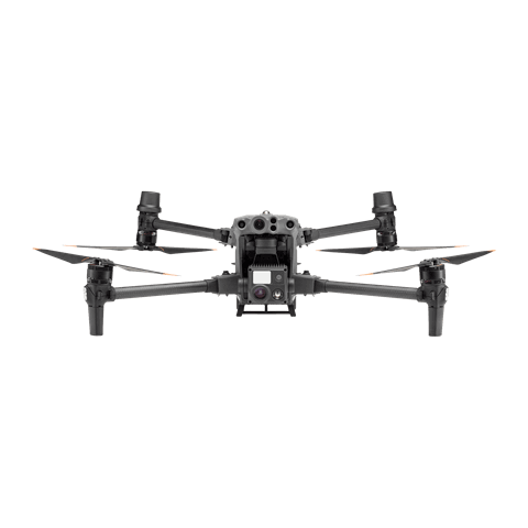
Weight: Approx. 6.47 kg(with single downward gimbal and two TB65 batteries).

Max Flight Time: 55 minutes.

Sensing system: Six-directional sensing and positioning.

Environment Adaptability: IP55, Max Service Ceiling Above Sea Level 7,000 m (with 1676 propellers,without other payload); Max Wind Resistance 12 m/s.

Learn more ›

Payload And Software

DJI Terra

Modeling and flight mission plan

Learn more ›
Zenmuse L2

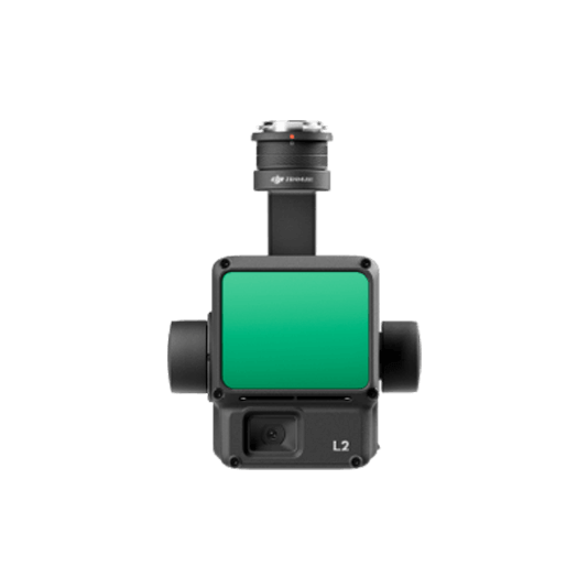
Integrates frame LiDAR, a self-developed high-accuracy IMU system, and a 4/3 CMOS RGB mapping camera. 2.5 km2 covered in a single flight. Detection Range 250m @10% reflectivity, 100klx. Effective Point Cloud Rate: 240,000 pts/s. Supports 5 Returns. Turnkey Solution.

Learn more ›
DJI Pilot 2

Ground control

Workflow

  1. Data Collection:
    • – Using the DJI Pilot 2 app and the 3D Mapping Flight Mission feature, captured the data to generate a 3D model of the forest.
  2. Data Processing:
    • – Input the data to DJI Terra, then reconstuct a high resolution 3D model.
  3. Data Analysis:
    • – Perform point cloud classification to analyze forest status and make accurate decisions. Import the resulting point cloud into a third-party software for further forest management and analysis.

Contact Us

For more information about product demo or trial, leave your contact information in the form below.
You can also reach out to your local dealer for more information.