Free Repairs
Unlimited repair incidents covered within the annual service limit.

Aerosmart UAV Trading L.L.C. is a tech company that specialises in drones and solutions in the UAE and across the GCC.
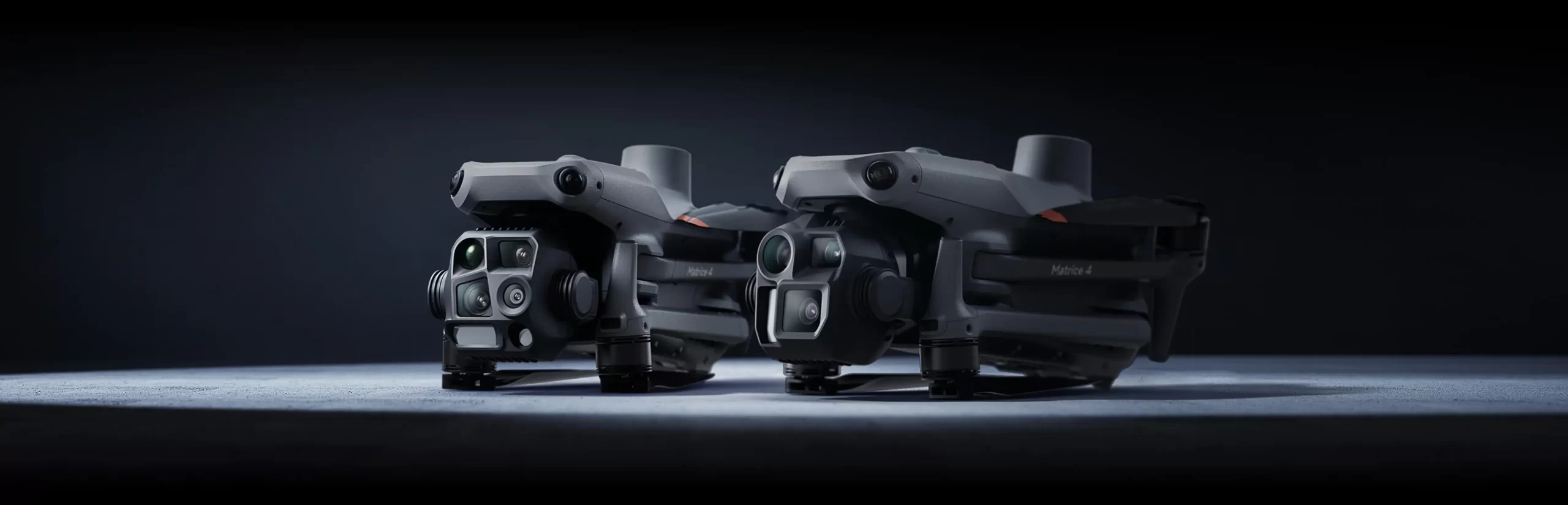
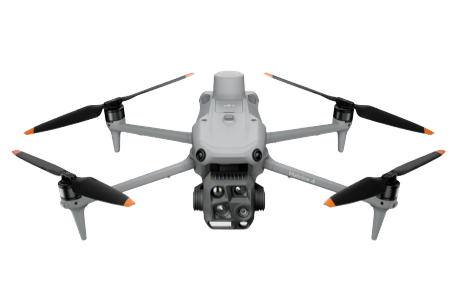
Flagship Intelligent Multi-Sensor Compact Drone
The Age of Intelligent Flight
Watch Video ▶
Onboard detection models identify vehicles, vessels, and search-and-rescue subjects automatically during both routine patrols and emergency response flights. The detection layer switches between models based on operational requirements, expanding what the aircraft can identify across different mission types. High-resolution grid photography and robust subject tracking run on the same platform, keeping capability broad without requiring separate hardware for each task.
Cruise mode holds the aircraft on a set heading without continuous stick input from the operator, making extended long-distance monitoring flights significantly less physically demanding to sustain.
During emergency or disaster response, the aircraft calculates its own route to a designated point, adjusting flight path and speed around the surrounding environment automatically reaching the location without requiring manual navigation from the operator.
Smart Track locks onto a subject with precise positioning and adjusts zoom automatically to maintain clear framing as the target moves. If the subject disappears behind an obstruction momentarily, the system reacquires it automatically when it reappears without operator input.
POI orbits a designated structure or location continuously, enabling sustained close observation and 3D model capture in a single automated pass that significantly accelerates fixed-point observation and structural modeling workflows.
The DJI Matrice 4E wide-angle camera triggers at 0.5-second intervals in both orthophoto and oblique capture modes, sustaining high-speed multi-angle aerial data collection without gaps in coverage. With mapping flight speeds reaching 21 m/s, large area survey assignments complete in a fraction of the time equivalent fixed-interval systems require.
Five-directional oblique capture lets the DJI Matrice 4 Series gimbal rotate and photograph from multiple angles in a single pass covering what previously required separate flights from different headings. The result is complete multi-face model data collected more efficiently, directly improving the economics of small drone oblique photogrammetry programs.
The DJI Matrice 4E captures lateral imagery simultaneously during standard orthophoto collection, reducing the lateral overlap needed and enabling a single flight to cover 2.8 square kilometres of mapping area. No separate elevation optimisation pass is required elevation accuracy improves as part of the standard workflow. Processing through DJI Terra further accelerates reconstruction without compromising the final output quality.
Smart 3D Capture on the DJI Matrice 4E starts with a rough model generated directly on the DJI RC Plus 2 Enterprise remote controller from an initial flight. That rough model then drives precise route generation that follows the actual surface geometry of the target structure making detailed measurement and modelling of irregular buildings accurate and repeatable. Virtual route preview and waypoint photo display let operators check flight safety and coverage before committing to the detailed capture flight.
Paired with Manifold 3, the DJI Matrice 4E gains Smart 3D Explore capability — the onboard computing power plans safe flight routes automatically around the target object’s actual environment and builds a rough 3D model that displays on the remote controller in real time. The close-range photogrammetry workflow compresses significantly, removing the iterative planning steps that slow down complex structure capture.
The DJI AL1 Spotlight reaches 100 metres with two operating modes Always-On for sustained illumination and Strobe for attention-signalling scenarios. Gimbal connection links the spotlight’s aim to camera movement, keeping the illuminated area aligned with what the camera is pointing at without requiring a separate operator to manage the light. Single-object focus and wide-FOV modes adapt the coverage pattern to match the task.
DJI Pilot 2 received a full interface update a customisable intelligent function toolbar and support for all current flight route types across the Matrice 4 Series mission profile.
Mobile SDK 5 gives development teams a fully open-source foundation for building custom control applications on the DJI Matrice 4 Series, with production code samples from core DJI Pilot 2 modules as a proven starting point.
Learn More ↗The MQTT-based Cloud API in DJI Pilot 2 connects the DJI Matrice 4 Series directly to third-party platforms hardware status, live video, and photo data all accessible through the API without building a dedicated application.
Learn More ↗The DJI Terra API brings automated 2D and 3D reconstruction capability into external platforms through direct integration. Photogrammetry workflows customise to match specific output requirements, allowing DJI Matrice 4E survey results to fit directly into the GIS, construction, and asset management systems that industry teams already use.
Learn More ↗Model training tools and a structured third-party certification process open the DJI Matrice 4 Series’ onboard computing to custom algorithm development, expanding intelligent detection applications beyond the built-in model library.
Learn More ↗Payload SDK integration via E-Port and E-Port Lite both with encryption authentication extends the DJI Matrice 4 Series’ application range to include specialist third-party sensors and mission-specific hardware.
Learn More ↗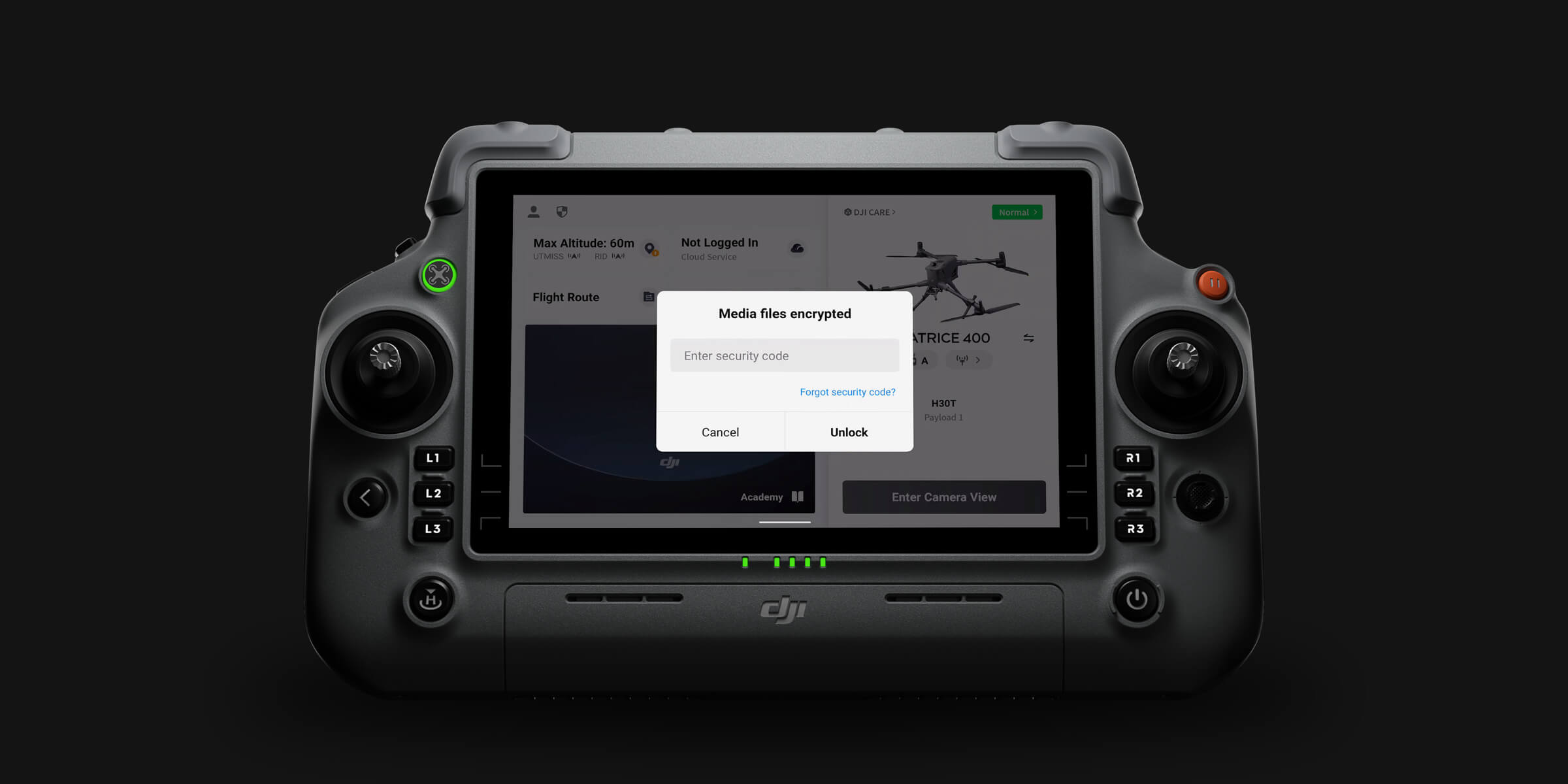
Local Data Mode
One-Tap Clear All Device Data
AES-256 Video Transmission Encryption
Cloud API
Unlimited repair incidents covered within the annual service limit.
One flyaway incident covered annually.
Shared limit for maximum protection
Free Mail-in Repairs, Hassle-Free Service
In addition to the standard warranty, an extra 1-year warranty service is provided. Major parts are covered by the official warranty, with support provided by our professional engineers.
Your journey into the extraordinary begins here. Share your details for a personalized DJI Matrice 4 Series quote and let your imagination soar.
✅ Thank you for reaching out. Your message has been successfully sent, and our team will get in touch with you shortly.