Aerosmart Drones | All types drones

Aerosmart UAV Trading L.L.C. is a tech company that specialises in drones and solutions in the UAE and across the GCC.
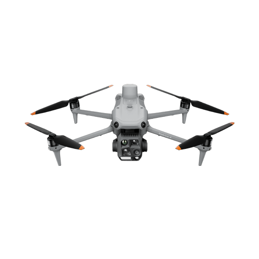
Our Office

Office 203, Al Tayer Commercial Building,
Rolla Street, Bur Dubai, UAE

Follow Us

Progress Management


Painpoints

  • Lack of up-to-date visual progress information.
  • Inefficient collaborations and processes.
  • Increased project costs from inefficient project management and rework.

Advantages

  • Generate highly-accurate 2D and 3D models to monitor progress and easily compare with historical data.
  • Easily share drone data between teams for more informed decision-making.
  • Stay on budget by collecting accurate data faster and more frequent.

Automated Routine Construction Site Monitoring Solution

The DJI Dock 3 allows you to automate recurrent construction site monitoring tasks effortlessly. Schedule remote data collection flights and upload collected data to DJI FlightHub 2 or your preferred Construction Management Software for timely project progress checks.

  • Schedule routine data collection flights over the construction site to efficiently track project progress.
  • Centimeter-level data thanks to its mechanical shutter and RTK capability.
  • Obtain multiple data outputs such as 3D Models, DSM, DEM, Point Clouds, and Orthomosaic Images to gain more insights into the construction status.
  • Upload and analyze the collected data to DJI FlightHub 2 or your preferred Construction Management Software to enhance cross-team collaboration.
Contact Us

Drone Platform

DJI Matrice 4D

Weight: 1850 g

Max Flight Time: 54 minutes

Environment Adaptability:IP55 rating, max takeoff altitude 6500 m, max wind speed resistance 12 m/s

Sensing System: Omnidirectional binocular vision system, supplemented with a 3D infrared sensor at the bottom of the aircraft

Mechanical Shutter Speed: 2-1/2000 s, minimum photo interval 0.5 s

Wide-Angle Camera: 4/3-inch CMOS, 20MP effective pixels

Medium Tele Camera: 1/1.3-inch CMOS, 48MP effective pixels

Telephoto Camera: 1/1.5-inch CMOS, 48MP effective pixels

Laser Rangefinding: 1800m measurement range (1 Hz) @20% reflectivity target

Learn more ›
DJI Dock 3

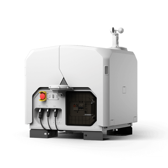
Weight: 55 kg (without the drone)

Size:1760×745×485 mm (L×W×H, dock cover opened)

Environment Adaptability:-30° to 50° C (-22° to 122° F) operating temperature, IP56 rating, maximum operating altitude 4500 m

Max Operating Radius: 10 km

Charging Time: 27 minutes

Security Camera (Internal) Resolution: 1920×1080

Learn more ›

Payload And Software

DJI FlightHub 2

Drone and dock’s cloud management system

Learn more ›

Workflow

  1. Data Collection:
    • – Plan a routine 2D map mission for regular orthomosaic data acquisition or a routine waypoint mission for regular site video recording and pano stitching.
  2. Data Processing:
    • – DJI FlightHub 2 will automatically process the data for DOM, DSM, Point Cloud, and 3D model outputs.
  3. Data Analysis:
    • – Compare historical site data with the most current site map to track progress.

Portable Drone Surveying & Mapping Solution

The DJI Matrice 4E is a portable surveying and mapping drone suitable for single-pilot operations. Paired with DJI Terra, it can generate accurate 2D and 3D models with significant reduction on the ground control points.

  • Portable solution, easy to operate and to carry across multiple construction sites.
  • Centimeter-level data thanks to its mechanical shutter and RTK capability.
  • Obtain multiple data outputs such as 3D Models, DSM, DEM, Point Clouds, and Orthomosaic Images to gain more insights into the construction status.
Contact Us

Drone Platform

DJI Matrice 4T

Weight: 1219 g (with propellers)

Max Flight Time (without wind): 49 minutes

Environment Adaptability: Max takeoff altitude 6000 m, max wind speed resistance 12 m/s

Sensing System: Omnidirectional binocular vision system, supplemented with a 3D infrared sensor at the bottom of the aircraft

Mechanical Shutter Speed: 2-1/2000 s, minimum photo interval 0.5 s

Wide-Angle Camera: 4/3-inch CMOS, 20MP effective pixels

Medium Tele Camera: 1/1.3-inch CMOS, 48MP effective pixels

Telephoto Camera: 1/1.5-inch CMOS, 48MP effective pixels

Laser Rangefinding: 1800m measurement range (1 Hz) @20% reflectivity target

Learn more ›

Payload And Software

DJI Pilot 2

Ground control

DJI Terra

Modeling and flight mission plan

Learn more ›

Workflow

  1. Data Collection:
    • – Plan a 2D map mission for regular orthomosaic data acquisition or a waypoint mission for site video recording and pano stitching.
  2. Data Processing:
    • – Import to DJI Terra to process for DOM, DSM, Point Cloud, and 3D models.
  3. Data Analysis:
    • – Import DJI Terra outputs to DJI FlightHub 2 or preferred Construction Management Software for building progress management.

Contact Us

For more information about product demo or trial, leave your contact information in the form below.
You can also reach out to your local dealer for more information.